Hurricane Simon brought heavy rain and powerful winds to Mexico’s Pacific coast Monday, raising fears of further flooding and landslides as rescue crews searched for missing people following deadly storms. At least five people were reported dead in affected areas, including four in Baja California and one in Guerrero, while military helicopters rescued 32 people stranded at a ranch surrounded by floodwaters.
Western Mexico faced another round of dangerous weather Monday as Hurricane Simon swept the region with strong winds and heavy rain, threatening communities still recovering from the destruction caused by earlier tropical storms.
Although the Category 2 hurricane remained offshore, its outer bands battered coastal areas near Puerto Vallarta, bringing heavy rainfall and strong winds to communities between the Sierra Madre mountains and the Pacific Ocean. The storm raised concerns about additional flash floods, overflowing rivers and landslides, particularly in areas where the ground was already saturated by previous rainfall.
At the same time, officials in the southwestern United States began lifting most flood advisories after the remnants of Tropical Storm Rachel caused flooding in Las Vegas over the weekend. The severe weather across the region showed how tropical systems can continue to cause dangerous conditions even after weakening or moving away from their original paths.
In Mexico, emergency crews faced a growing challenge as floodwaters rushed through neighborhoods, roads became blocked and families waited anxiously for information about missing relatives. Rescue workers moved into damaged areas to search for survivors, while authorities coordinated efforts to assist residents affected by the rising water.
In Baja California, a northwestern Mexican state along the Pacific coast, rescue teams searched parts of the coastal city of Ensenada on Monday after floodwaters swept through residential neighborhoods. The rushing water carried away vehicles, damaged houses and scattered debris across streets, leaving residents to deal with the destruction.
At least four people died in the state following the impact of the remnants of Tropical Storm Rachel, according to local emergency officials. Several others remained missing as search-and-rescue operations continued in communities affected by the flooding.
For some residents, the disaster began during the night, when heavy rain and sudden power outages left little warning of the danger approaching their homes. Johana Nuriulu, a resident of an affected neighborhood, said the flooding began after the electricity went out. In the darkness, residents heard a powerful sound that reminded them of ocean waves crashing nearby.
READ OTHER ARTICLES:
- Robert E. Hall and Michael Woodford Win Nobel Prize in Economics
- US Supreme Court Gives FCC More Time in Political Ad-Rate Dispute
- Russia Denies Plague as Lab Worker Dies, World Demands Answers
- Francis Leo Marcos Arrested Again Over Three Cyberlibel Cases
- Housing Fury Erupts Across Spain as Protesters Clash With Police
- The Timeless Bond and Contemporary Crossroads of Philippines–China Relations
“We heard a loud noise that sounded like ocean waves, but really loud,” Nuriulu said.
Concerned by the unusual noise, she went outside to see what was happening. She soon discovered that a nearby stream had overflowed, sending a strong current of water rushing into the neighborhood. The water spread rapidly through streets and homes, sweeping away vehicles and personal belongings. Residents had little time to react as the current carried away items that families depended on for their daily lives.
“Everything was being dragged away,” Nuriulu said.
The flooding left homes damaged and streets covered with debris. As the water moved through the neighborhood, residents struggled to determine the extent of the destruction and whether their properties were safe to return to.
For affected families, the immediate concerns were finding secure shelter, checking on relatives and recovering whatever possessions remained. The damage also threatened to disrupt normal activities as residents dealt with the loss of electricity, transportation and access to essential services.
The emergency extended beyond Ensenada, where overflowing rivers and landslides blocked roads in other parts of Baja California. Several communities became difficult to reach, leaving residents isolated and complicating efforts by emergency personnel to deliver assistance.
In some locations, floodwaters and damaged roads prevented people from leaving safely. Rescuers had to find alternative ways to reach stranded residents, including using aircraft to access places cut off by the rising water.
On Monday afternoon, the Mexican military sent helicopters to rescue 32 people from a ranch in Ensenada. State officials said 22 of those rescued were foreign nationals, while Baja California Gov. Marina del Pilar Ávila reported that 13 members of the group were young people.
Gen. Laureano Carrillo, the state’s secretary of security, said some of the people stranded at the ranch were missionaries who had gathered for a meeting. The group included German and American nationals.
The rescue operation highlighted the difficulties emergency crews faced in reaching people surrounded by floodwaters. With some roads blocked and other routes rendered unsafe, helicopters provided a way to evacuate people who might otherwise have remained stranded.
The successful rescue brought dozens of people out of an isolated area, but authorities continued to search for others who had disappeared during the severe weather.
Baja California Civil Protection Coordinator Ignacio Lozoya said Monday evening that officials had recovered four bodies in Ensenada. The victims included a 13-year-old girl whose body was found Sunday, along with two women and a 4-year-old boy recovered Monday.
Six people were still missing, Lozoya said. Four were reported missing in Ensenada, while the remaining two were a father and son from the town of San Felipe.
The father and son had gone fishing Saturday but never returned. Their disappearance raised concerns among relatives and authorities, who continued efforts to locate them.
The search was complicated by dangerous weather conditions, strong currents and damage to roads and other infrastructure. In areas where water levels had risen quickly, rescuers had to contend with debris and difficult terrain while trying to reach places where missing people might be found.
Ávila said about 14,000 federal and state personnel had been deployed throughout Baja California to assist affected communities and respond to the emergency.
The large-scale deployment was intended to support rescue operations, help residents in need and address the damage caused by flooding and landslides. Emergency personnel were particularly important in areas where damaged roads and rising water had left communities cut off from outside assistance.
Authorities urged residents in vulnerable areas to remain alert, follow official warnings and stay away from dangerous locations while rescue operations continued. The search for missing people remained a priority as officials worked to assess the full extent of the damage.
Farther south, communities in Guerrero also faced dangerous conditions as Hurricane Simon brought strong winds and heavy rain to the state’s Pacific coast.
Gov. Evelyn Salgado said the storm toppled trees and electrical poles, blocked roads and flooded homes in several communities, including areas around Acapulco. The major seaport is one of Mexico’s best-known beach destinations and attracts both domestic and international tourists.
Fallen trees and power poles created hazards for residents and motorists, while blocked roads made it harder to travel between communities. Flooded houses left families facing damage to their property as emergency crews assessed conditions and worked to respond to calls for help.
The storm also claimed a life in Chilpancingo, Guerrero’s capital, where a 71-year-old man died after a wall collapsed, Salgado said.
The fatal incident underscored the dangers that heavy rainfall and strong winds can pose to buildings and other structures. Walls weakened by poor conditions or exposed to intense weather can collapse, putting people nearby at risk.
As the storm continued to affect western Mexico, forecasters warned that more dangerous weather could develop in the coming days.
The U.S. National Hurricane Center reported late Monday that Simon had maximum sustained winds of about 155 kilometers per hour, equivalent to 100 miles per hour. The hurricane was expected to maintain its strength through the middle of the week as it slowly approached Mexico’s western coastline.
Forecasters warned that heavy rain could cause life-threatening flooding and mudslides before the storm potentially reached land late Friday.
Even while Simon remained offshore, its outer bands were capable of bringing hazardous conditions to coastal communities and areas farther inland. Heavy rainfall can overwhelm drainage systems, push streams and rivers beyond their banks and cause water to accumulate rapidly in low-lying neighborhoods.
The risk can be especially serious in mountainous areas, where rainwater flows down steep slopes and can cause rivers to rise within a short period. When the ground becomes saturated, hillsides may also become unstable, allowing mud, rocks and other debris to slide onto roads and into nearby communities.
These conditions can make evacuation difficult, particularly when landslides block the main roads connecting remote communities to larger towns. Flooded routes can also prevent emergency crews from reaching residents who need food, medical assistance or a safe place to stay.
For communities already damaged by previous storms, another round of heavy rain could create additional problems. Flooded homes may take longer to repair, damaged roads may remain impassable, and power outages could continue to affect households and businesses.
In Puerto Vallarta, one of Mexico’s most popular Pacific coast destinations, conditions appeared to improve somewhat Monday as rainfall eased and some businesses began reopening.
Workers removed wooden boards from storefronts and other businesses that had been secured ahead of the storm. The activity suggested that some business owners were cautiously preparing to resume normal operations after the latest round of bad weather.
However, the improvement offered little certainty about what would happen next. With Simon still moving near the coast, residents and business owners remained concerned that stronger winds and heavier rainfall could return.
The city’s international airport suspended operations until Tuesday morning, disrupting travel plans for passengers scheduled to arrive in or depart from the resort destination.
The closure also affected the tourism industry, which supports hotels, restaurants, tour operators, transportation providers and many local workers. When airports suspend flights and businesses close because of severe weather, visitors may be forced to change their plans, while employees and business owners can lose income.
A prolonged disruption could create additional financial pressure for businesses that were already dealing with the effects of the storm. Even after the weather improves, companies may need time to inspect their properties, repair damage and determine whether it is safe to reopen.
For tourism workers in Puerto Vallarta, the uncertainty surrounding Simon made it difficult to know when normal operations could resume.
Noelia Carrillo, who works for a tourism agency in the city, said residents should remain cautious because the storm’s eventual path was still unclear.
“Personally, I think we should remain on alert because we don’t really know whether it will arrive, move elsewhere or dissipate,” Carrillo said.
Her comments reflected the concerns of residents who were trying to prepare for a storm that could change direction or weaken before reaching land. While a temporary break in rainfall offered some relief, it did not eliminate the possibility of further dangerous weather.
Local officials still needed to monitor Simon’s movement, evaluate the risk of additional flooding and determine whether roads, airports and other public services could operate safely.
The situation also demonstrated why a hurricane does not have to make direct landfall to cause serious damage. Strong winds and heavy rain can extend far beyond the storm’s center, affecting communities that may initially appear to be outside its main path.
Rainbands can produce sudden downpours, while already swollen rivers may continue rising after the heaviest rainfall ends. Waterlogged ground can also increase the chance of landslides, particularly when more rain falls over a short period.
Across Baja California and Guerrero, authorities faced the dual challenge of helping residents recover from existing damage and preparing for another possible round of severe weather.
Rescue teams continued looking for missing people, government personnel assisted affected communities, and families began assessing the condition of their homes and belongings. In isolated areas, restoring road access was especially important because emergency supplies and other assistance could not easily reach residents while transportation routes remained blocked.
The damage extended beyond flooded streets and destroyed property. Power outages and transportation disruptions threatened to interrupt work, school and other daily activities. Families whose vehicles or household belongings were swept away also faced the prospect of costly repairs and replacements.
For some residents, the effects could continue long after floodwaters receded. Cleaning damaged homes, replacing essential items and repairing structures can take considerable time, especially when roads remain blocked or access to supplies is limited.
As Simon continued moving near Mexico’s Pacific coast, emergency officials faced growing pressure to prepare vulnerable communities for the possibility of additional rain and strong winds.
Forecasters continued tracking the hurricane and warning about the dangers of flash flooding, mudslides and rising rivers. Residents in threatened areas needed timely information to make decisions about travel, shelter and possible evacuation.
The situation in western Mexico showed how successive tropical weather systems can place communities under sustained pressure. While some areas were still searching for missing residents and recovering from earlier flooding, others were preparing for another storm that could bring additional destruction.
The combined effects of damaged infrastructure, isolated communities and uncertain weather conditions made emergency response more difficult. Rescue workers had to balance the urgent need to locate missing people with the need to protect residents from further danger.
For families affected by the flooding, the priority remained finding missing loved ones, securing safe shelter and beginning the difficult process of rebuilding their lives. Government agencies continued coordinating rescue and relief efforts while monitoring the hurricane’s progress.
With Simon expected to remain a hurricane through midweek and potentially approach Mexico’s western coast later in the week, officials and residents remained on alert. Although some communities experienced a temporary improvement in the weather, the threat of further heavy rainfall had not passed.
The coming days were expected to be important for rescue operations, recovery efforts and preparations for any additional impact from the storm. For communities already struggling with flooded homes, blocked roads and missing relatives, the main concern was whether they would face another round of dangerous weather before they had a chance to recover.
Storm Rachel Pounds Southern California With Huge Waves as Flooding Disrupts Las Vegas and Utah
Storm Rachel weakened into a post-tropical cyclone as it moved north toward Southern California, but it continued to bring dangerous conditions to parts of the western United States. Massive waves battered coastal communities, damaged waterfront structures, and threatened homes, while heavy rainfall raised concerns about flooding in Nevada, Utah, and other parts of the Southwest. Some residents were forced to evacuate as authorities warned that hazardous weather could persist even after the storm weakened.
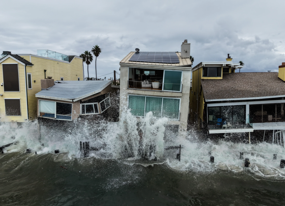
Along the Southern California coast, powerful waves crashed against beaches and nearby communities, tearing apart a boardwalk and slamming into homes in Long Beach. The rough surf created dangerous conditions for people living near the ocean, where repeated waves can damage buildings, flood streets, and destroy structures along the shoreline. As waves continued to surge toward residential areas, some residents had to leave their homes to escape the danger.
Although Rachel had weakened considerably, its effects remained evident along the coast. Large waves continued to threaten waterfront properties, showing that a storm can remain dangerous even after it loses its tropical characteristics. Changes in atmospheric conditions and interactions with cooler ocean waters can weaken a storm, but the powerful surf, strong winds, and heavy rain it produces may continue to cause damage.
The effects extended far beyond the coastline. In Las Vegas, heavy rainfall brought an unusual amount of water to the desert city, contributing to flooding and tying the city’s record for the most rainfall recorded on an October day. According to the U.S. National Weather Service, Las Vegas received 1.08 inches, or 2.74 centimeters, of rain through Sunday morning, matching a record set in 1947.
The rainfall was significant for a city that typically experiences long periods of dry weather. When heavy rain falls over a short period, streets and drainage systems can quickly become overwhelmed, allowing water to collect in areas that are not designed to handle sudden downpours. The combination of intense rainfall and urban development can make flash flooding a serious threat, particularly in low-lying areas and along roadways.
Videos shared on social media captured the force of the flooding near the Las Vegas Strip, a major tourist destination known for its casinos, hotels, and entertainment attractions. The footage showed a powerful current of water rushing through a street, with a Ferris wheel and several casinos visible in the background. The scenes illustrated how quickly a heavy downpour can turn familiar city streets into dangerous waterways.
Flash floods can develop with little warning when rainfall exceeds the ground’s ability to absorb water or the drainage system’s capacity to carry it away. Water can rush along roads, pour into underpasses, and accumulate in low-lying neighborhoods. Even seemingly shallow floodwaters can conceal dangerous debris, damage vehicles, and sweep people off their feet. Strong currents can also carry away objects and make roads impassable within minutes.
Andrew Orrison, a meteorologist with the National Weather Service, warned that localized flash flooding remained possible in the Las Vegas area on Monday. Although the worst conditions associated with Rachel had passed, he said unsettled weather was still lingering in the region.
“We’ve seen the worst of what Rachel brought … but unfortunately we are looking at the disturbed weather still lingering,” Orrison said.
His comments highlighted the importance of remaining alert even after the main storm has moved away. Flood risks can persist after the heaviest rain stops because water may continue flowing through drainage channels, streams, and neighborhoods. Additional showers can also worsen existing conditions, particularly in places where floodwaters have not receded or the ground remains saturated.
By late Monday, flood advisories had been lifted across much of Utah, Arizona, and other parts of the Southwest. However, the effects of the recent rainfall continued to disrupt activities in some communities. In Utah, flooding forced dozens of runners and volunteers participating in the Moab 240 ultramarathon to evacuate after they became stranded by rising water.
The Moab 240 is a demanding endurance race that takes participants across rugged terrain near Canyonlands and Arches national parks. Runners and support crews must cover long distances through remote landscapes, where sudden changes in weather can create serious challenges. Heavy rain can quickly turn trails muddy, flood roads, and send water rushing across areas that are usually dry.
The flooding left dozens of participants and volunteers needing evacuation on Sunday. When rising water blocks access to trails or makes nearby roads unsafe, race organizers and emergency responders must act quickly to move people to safer locations. Reaching stranded participants can be especially difficult in remote areas, where access routes may be limited and emergency crews must navigate challenging terrain.
The incident also highlighted the risks of holding outdoor events during unstable weather. Runners and volunteers may be far from shelters, medical facilities, and emergency services. Floodwaters can rise rapidly, leaving little time for people to find a safe route out. Even experienced athletes can face serious danger when trails, roads, or stream crossings become flooded.
Weather officials clarified that the additional rain expected across parts of the western United States was not directly associated with Rachel. Instead, a separate weather system was moving across the region, bringing more unsettled conditions as the weakened storm continued northward.
Orrison said the separate system was expected to bring additional precipitation through the middle of the week, with the rain forecast to end by Wednesday. As a result, some communities could continue to experience wet weather even as the immediate effects of Rachel began to ease.
The distinction between the two weather systems is important because the departure or weakening of one storm does not guarantee an immediate return to clear skies. Separate systems can move across the same region in succession, bringing more rain to places already dealing with flooded streets, damaged infrastructure, and travel disruptions. When additional rainfall arrives before floodwaters have fully receded, the risk of further flooding can increase.
Across Southern California and the Southwest, the combination of powerful coastal waves, unusually heavy rainfall, and flash flooding demonstrated how unsettled weather can affect communities in different ways. Along the Pacific coast, residents faced dangerous surf that damaged waterfront structures and threatened homes. Farther inland, heavy rain overwhelmed streets and created hazardous conditions for motorists, residents, and people taking part in outdoor activities.
In Long Beach, the main concern centered on the destructive force of waves pounding the shoreline. In Las Vegas, the rainfall record and flooding highlighted the dangers of intense downpours in a desert environment. Meanwhile, in Utah, the evacuation of ultramarathon participants showed how quickly flooding can disrupt activities in remote natural areas.
Despite the lifting of many flood advisories by late Monday, residents were urged to remain cautious while unsettled weather continued. Authorities generally advise people to monitor official weather alerts, avoid flooded streets, and stay away from fast-moving water. Drivers should never attempt to cross flooded roadways because the depth and strength of the current can be difficult to judge. Even a relatively small amount of moving water can make a vehicle difficult to control, while deeper water can sweep it away.
People living near rivers, drainage channels, and low-lying areas should also remain alert to changing conditions, particularly when more rain is expected. Floodwaters can continue moving through communities even after the skies begin to clear, and debris left behind can create additional hazards.
As the region awaited the end of the additional rainfall forecast for Wednesday, the damage and disruption caused by the storm and the separate weather system remained a concern. Damaged coastal structures in Southern California, flooded streets in Las Vegas, and the evacuation of runners and volunteers in Utah showed that dangerous weather can continue to affect a wide area even after a storm loses strength.
The situation underscored the importance of taking weather warnings seriously and preparing for rapidly changing conditions. Although Rachel had lost its tropical strength, the large waves and flooding associated with the unsettled weather continued to threaten lives, property, transportation, and outdoor activities across parts of the western United States.
Hurricane Isaias Knocks Out Power for Thousands Across the Southeastern United States
Thousands of residents in Florida and Alabama remained without electricity after Hurricane Isaias swept through the Southeast, bringing powerful winds and heavy rain. At least four deaths have been connected to the storm, as utility workers raced to restore power and local officials worked to help communities recover.
Thousands of people across the southeastern United States were still waiting for their electricity to return Monday evening after Hurricane Isaias moved through the region, damaging power lines and interrupting essential services. Repair crews continued working to reconnect affected homes and businesses while authorities monitored conditions and assessed the damage left behind by the storm.
Isaias, the Atlantic season’s first hurricane, struck the Gulf Coast on Friday near Destin, Florida. The coastal city is a popular vacation destination known for its sandy beaches, hotels, high-rise buildings, and busy tourist businesses. The storm reached the area as a Category 2 hurricane, unleashing strong winds and heavy rainfall that threatened homes, commercial properties, and public infrastructure.
At least four deaths have been associated with Isaias, underscoring the serious dangers that powerful storms can bring to affected communities. Although the hurricane weakened as it moved farther inland, its impact continued to disrupt daily activities, particularly in neighborhoods where electricity remained unavailable.
After crossing into Florida, Isaias moved into Alabama, carrying tropical-storm-force winds and continued unsettled weather. The system gradually weakened as it traveled farther north, reducing the immediate danger associated with hurricane conditions. However, the loss of electricity remained a major concern for residents who were forced to manage without many of the services they normally depend on.
According to PowerOutage.com, around 106,000 electricity customers across Florida’s Panhandle and southern Alabama were still without power by Monday evening. The outages affected thousands of households and businesses that depend on reliable electricity for lighting, refrigeration, air conditioning, communications, and other basic needs.
Extended power outages can create serious difficulties, especially during periods of warm weather. Without air conditioning, indoor temperatures can quickly become uncomfortable, particularly for young children, older adults, and people who are vulnerable to extreme heat. Families may also have trouble preserving food, charging their phones, and receiving important weather updates or emergency announcements.
The disruption can also affect local businesses and the wider economy. Grocery stores, restaurants, hotels, and small businesses may have to suspend operations or reduce their services until electricity is restored. Business owners may face additional expenses if refrigerated food spoils, equipment is damaged, or buildings require repairs before they can safely reopen.
Restoring power after a hurricane is often a difficult and time-consuming process. Strong winds can knock down electrical lines, break utility poles, and scatter trees and other debris across roads, making it harder for repair crews to reach damaged areas. Workers must inspect the electrical network, identify the most serious problems, and complete repairs while following safety procedures to prevent further accidents.
Despite these challenges, utility companies continued their efforts to restore service as the number of outages gradually declined. Florida Gov. Ron DeSantis said he expected nearly all affected customers to have their electricity back by Tuesday night. The announcement gave residents hope that conditions would soon improve, although some homes and businesses could experience longer delays if their local power infrastructure had suffered extensive damage.
DeSantis also ordered schools across Florida to reopen Wednesday as the state prepared to resume normal activities. The decision reflected expectations that conditions would improve enough for students, teachers, and school employees to return to their regular schedules after the storm disrupted communities.
However, the reopening of schools and the restoration of electricity do not necessarily mean that all storm-related problems have been resolved. Residents may still need to remove fallen branches, inspect their properties, clean up debris, and replace food lost during power outages. Some businesses may also require additional time to repair equipment and prepare their facilities for customers.
Local authorities and emergency personnel must continue watching for hazards that can remain after a storm has passed. Fallen trees, damaged roads, standing water, and exposed electrical wires can pose risks to residents and cleanup workers. Even when the weather begins to improve, damaged infrastructure can make certain areas unsafe.
Residents are urged to avoid fallen power lines and report them to the appropriate utility company or emergency authorities. A wire that appears harmless or disconnected may still carry electricity and cause severe injury or death. People should also stay away from flooded roads and damaged electrical equipment while repair and cleanup operations continue.
Weather forecasts offered some encouraging news for the affected region. Drier conditions were expected over the following several days across parts of the mid-Atlantic and the Southeast, including areas of the southern Appalachian Mountains. The expected change in weather could give residents and emergency crews more favorable conditions for clearing debris, inspecting damaged properties, and completing repairs.
A break from widespread rain can make recovery efforts easier because workers can spend more time outdoors without having to deal with additional precipitation. It can also help communities concentrate on restoring essential services and addressing damage without facing another round of disruptive weather.
However, the improving forecast did not mean temperatures would necessarily become cooler. Some areas were expected to experience above-normal temperatures during the week. Orrison described the anticipated conditions as “a little summerish,” indicating that warmer weather could settle across parts of the region as Isaias moved farther away.
While the return of drier weather could help with recovery, higher temperatures may create additional problems for residents who remain without electricity. Homes without air conditioning can become increasingly hot, making it harder for families to remain comfortable while waiting for utility crews to complete repairs.
Residents can take simple steps to reduce the risks associated with heat during an extended outage. Drinking plenty of water, limiting strenuous outdoor activities during the hottest parts of the day, and seeking cooler locations when necessary can help protect vulnerable individuals. Checking on older relatives, neighbors, and people who may need additional assistance can also make a difference during the recovery period.
Portable generators can provide temporary electricity, but they must be used correctly. Generators should always be operated outdoors and far from doors, windows, and other openings because they produce carbon monoxide, an invisible, odorless gas that can be deadly. Using a generator inside a home, garage, or other enclosed space can expose people to dangerous levels of the gas.
For residents across Florida’s Panhandle and southern Alabama, the immediate priority remained restoring electricity and returning daily life to normal. Although Isaias had weakened and drier weather was expected, the thousands of remaining outages demonstrated that the effects of a hurricane can continue long after the storm itself has passed.
The expected return of power to nearly all affected customers by Tuesday night, along with the planned reopening of schools Wednesday, offered signs that recovery was moving forward. Nevertheless, the timeline depended on the progress of repair work and the condition of local electrical systems. Residents were encouraged to remain cautious and follow guidance from local authorities while crews worked to restore services.
The storm also served as a reminder of how quickly severe weather can affect entire communities. Beyond the immediate threat of strong winds and heavy rain, hurricanes can interrupt electricity, disrupt businesses, damage infrastructure, and leave families struggling to meet basic needs.
As recovery efforts continued, utility workers focused on reconnecting customers while residents prepared for the gradual return of normal routines. For thousands of households and businesses across the Southeast, restoring electricity remained one of the most urgent steps toward putting Hurricane Isaias behind them.
Hurricane Simon Intensifies, Raising Fears of Severe Flooding and Mudslides Along Mexico’s Pacific Coast
Hurricane Simon strengthened into a Category 2 storm Friday as it moved across the Pacific Ocean toward Mexico, prompting weather officials to warn that it could develop into a major hurricane over the weekend. Authorities began taking emergency measures, including suspending classes, evacuating residents from high-risk areas, and preparing shelters as communities braced for powerful winds, heavy rainfall, flooding, and possible mudslides.
The National Hurricane Center reported that Simon’s maximum sustained winds had reached nearly 100 mph, or 155 kilometers per hour. Forecasters expected the storm to intensify quickly over the following day, with the possibility of reaching major hurricane status by late Friday and becoming even stronger on Saturday.
The approaching hurricane placed several areas of southwestern Mexico on alert, particularly coastal communities that could experience dangerous weather conditions. Officials warned that the combination of heavy rain, strong winds, and rising floodwaters could threaten lives, damage property, and disrupt transportation.
Authorities urged residents and visitors to take precautions immediately rather than wait until the storm moved closer to land. Emergency preparations were considered especially important because Simon had shown unpredictable changes in direction, making it harder to determine exactly which communities would experience the worst conditions.
Under the Saffir-Simpson Hurricane Wind Scale, a storm becomes a major hurricane when its sustained winds reach at least 111 mph, or 179 kilometers per hour. This places it in Category 3 or higher, where the potential for severe damage increases significantly.
However, officials emphasized that a storm’s category does not tell the whole story. Even areas that escape the strongest winds can suffer serious damage from prolonged rainfall, flash flooding, overflowing rivers, and landslides. These dangers can develop quickly, leaving residents with little time to escape if they delay their preparations.
According to the National Hurricane Center, Simon was located about 210 miles, or 335 kilometers, south of Manzanillo and approximately 310 miles, or 500 kilometers, south-southeast of Cabo Corrientes along Mexico’s Pacific coast.
U.S. forecasters had issued a hurricane warning for sections of the country’s central and southwestern coastline, indicating that hurricane conditions could arrive within 36 hours. The warning gave local officials and residents a limited window to secure their homes, prepare emergency supplies, and move away from areas considered dangerous.
The storm was expected to produce particularly heavy rainfall across parts of Jalisco, Michoacán, Colima, and Nayarit. Forecasters warned that coastal communities could receive significant amounts of rain, raising the possibility of sudden flooding and mudslides in areas with steep terrain or poor drainage.
Heavy rain can quickly overwhelm drainage systems, forcing water into homes, businesses, streets, and low-lying neighborhoods. In mountainous areas, rain-soaked soil can become unstable, causing mud, rocks, and debris to slide down hillsides and threaten communities below.
Flooding can also affect areas far from the coast. Rivers and streams may rise rapidly after prolonged rainfall, while roads can become impassable as water spreads across low-lying sections. Emergency responders may also struggle to reach affected residents if major routes become blocked by floodwaters, fallen trees, or damaged infrastructure.
For these reasons, authorities encouraged residents to follow official weather bulletins and evacuation instructions closely. People were warned not to walk or drive through flooded roads because moving water can sweep away vehicles and people, even when the depth appears manageable.
In Jalisco, state officials moved quickly to prepare for the hurricane’s possible effects. The government suspended classes on Friday and Monday in 22 coastal municipalities to protect students and give communities more time to prepare for the expected severe weather.
Authorities also began evacuating dozens of people from locations considered vulnerable to flooding and other storm-related hazards. Moving residents to safer areas before conditions worsen can reduce the risk of emergency rescues during periods of strong winds and rising water.
Officials also called on tourism businesses in Puerto Vallarta to make sure that employees and visitors were accommodated in shelters or designated safe areas by Friday afternoon.
Puerto Vallarta is one of Mexico’s most popular vacation destinations, attracting travelers from across the country and abroad, including large numbers of American tourists. With the hurricane approaching, hotels, resorts, restaurants, and other businesses faced the challenge of protecting guests and employees while keeping everyone informed about potential dangers.
Visitors may be unfamiliar with local emergency procedures or unaware of the risks associated with hurricanes in the region. Authorities therefore stressed the importance of communicating clear safety instructions and ensuring that tourists knew where to go if evacuations became necessary.
Travelers were urged to follow government announcements instead of continuing with normal vacation activities. Depending on weather conditions, beach access, transportation services, and other tourism activities could be affected as the storm approached.
Sergio Ramírez, Jalisco’s director of civil protection, warned that delaying emergency preparations could put lives at risk.
“If we let our guard down and try to come up with a last-minute action plan, it is highly likely that lives will be lost,” Ramírez said.
His statement highlighted the importance of acting before dangerous conditions arrive. Emergency officials need sufficient time to organize shelters, move residents out of threatened areas, prepare rescue teams, and ensure that essential supplies are available.
Waiting until strong winds and heavy rain begin could make evacuation more difficult. Flooded roads, fallen trees, and power outages can interfere with transportation and communication, making it harder for authorities to reach people who need assistance.
Jalisco Gov. Pablo Lemus also called on the public to remain alert and follow reliable weather updates as Simon continued to change direction. He described the storm’s movement as highly unpredictable, noting that its path had shifted between the areas of Manzanillo and Puerto Vallarta.
Changes in a hurricane’s direction can make it difficult to identify which communities will face the greatest danger. Even a relatively small shift in its projected path can affect where the strongest winds and heaviest rainfall occur.
Officials cautioned residents against assuming they were out of danger simply because a forecast changed. A storm can still bring damaging rainfall and flooding to areas outside its projected center, particularly when its rain bands extend over a wide region.
Lemus said the one thing residents could count on was the threat of heavy rain along Jalisco’s coast.
“What is certain is that it will hit the coast of Jalisco with very heavy rains starting this Friday, throughout the weekend, and on Monday,” he said.
The prospect of several days of rain raised concerns about flooding that could continue even if Simon’s strongest winds remained offshore. When rain falls faster than the ground can absorb it or drainage systems can carry it away, water accumulates in streets, neighborhoods, and surrounding lowlands.
Prolonged rainfall can also saturate the soil, increasing the likelihood of landslides and mudslides. In communities near hillsides, residents may face additional danger from collapsing slopes, falling rocks, and debris carried downhill by runoff.
Coastal communities could experience several hazards at once, including powerful winds, rough seas, flooding, and disruptions to essential services. Homes and businesses may be damaged, while fallen trees and power lines can block roads and create additional safety risks.
Authorities advised residents in threatened areas to prepare emergency supplies, keep important documents protected, and identify safe locations before conditions deteriorated. They also urged people to limit unnecessary travel and avoid beaches, rivers, and other areas where rising water or strong currents could become dangerous.
While Jalisco prepared for Simon’s arrival, the neighboring state of Guerrero was already dealing with the effects of heavy rainfall associated with the storm. Officials suspended classes and nonessential activities in coastal communities and parts of the state’s central region after heavy rain began affecting the area on Thursday.
Acapulco, one of Mexico’s major Pacific port cities, experienced some of the worst flooding. Streets were inundated as water rushed through roadways, sweeping away vehicles and flooding homes and commercial establishments.
The flooding illustrated how quickly heavy rain can disrupt everyday life in densely populated areas. When drainage systems are unable to handle the amount of water falling over a short period, roads can turn into fast-moving channels, making travel dangerous for motorists and pedestrians.
Floodwater can also hide open drains, damaged pavement, electrical hazards, and debris. People who attempt to cross flooded streets may encounter stronger currents than expected, while drivers can lose control of their vehicles or become trapped as water rises.
Officials urged residents to stay away from flooded areas and avoid attempting to drive through moving water. Even when a road appears passable, the force of a current can carry away a vehicle or push it into deeper water.
Guerrero Gov. Evelyn Salgado said no deaths or injuries had been reported in connection with the flooding at the time of the announcement. However, the situation remained concerning as additional rainfall could cause more flooding and make already affected communities more vulnerable.
Emergency teams continued to monitor conditions and urged residents to follow safety instructions. Authorities also faced the challenge of assessing damage and helping affected households while preparing for the possibility of further heavy rain.
The U.S. Embassy in Mexico issued safety alerts for American citizens in areas affected by the storm. The guidance warned people against entering the water or walking along beaches during dangerous conditions and urged travelers to follow instructions from local authorities.
The warnings were particularly important for tourists who might be tempted to continue swimming, sightseeing, or spending time near the ocean despite deteriorating weather. Hurricanes can generate dangerous waves and currents, while floating debris and sudden changes in sea conditions can turn otherwise familiar beaches into hazardous areas.
Travelers were encouraged to monitor local announcements, remain in contact with their hotels or accommodations, and be ready to change their plans if officials ordered evacuations or restricted access to certain locations.
The effects of unsettled weather were not expected to be limited to southwestern Mexico. Farther north, Tropical Storm Rachel was forecast to approach Baja California, northwestern Mexico, and Southern California over the weekend.
At the time of the forecast, Rachel had maximum sustained winds of about 50 mph, or 85 kilometers per hour. Forecasters expected the storm to weaken as it moved, but warned that it could still produce heavy rain in parts of the region.
A weakening tropical storm can remain dangerous, particularly when it carries large amounts of moisture into areas vulnerable to flooding. Heavy rainfall can overwhelm drainage systems, disrupt road travel, and cause localized flooding even when winds are no longer strong enough to produce major structural damage.
Communities in Rachel’s projected path were advised to keep track of weather updates and prepare for possible disruptions. The storm added another concern for emergency officials monitoring weather conditions across the eastern Pacific and nearby regions.
The developments involving Simon and Rachel also underscored why weather agencies monitor more than a storm’s wind speed. Although the hurricane category is based on sustained winds, flooding and landslides can cause serious damage regardless of whether a tropical system is strengthening or weakening.
The severity of the impact often depends on local conditions, including the amount of rain that has already fallen, the landscape, the condition of drainage systems, and the number of people living in exposed areas. A storm that produces manageable rainfall in one location may cause serious flooding in another.
Tropical storm activity in the Pacific has been above average this season, according to reports on regional hurricane activity. Forecasters have linked the increased activity to the influence of a strong El Niño, a climate pattern that affects ocean temperatures and atmospheric conditions across the globe.
El Niño occurs when sea surface temperatures in parts of the central and eastern tropical Pacific become warmer than normal. This warming can influence wind patterns and other atmospheric conditions that help determine how tropical storms form and develop.
In the Pacific, El Niño can create conditions that favor increased tropical cyclone activity. However, the effects are not identical for every storm, and the number, strength, and paths of tropical systems can still vary throughout the season.
The same climate pattern typically reduces hurricane activity in the Atlantic by affecting atmospheric conditions in ways that can make storm development more difficult. Nevertheless, a less favorable environment does not eliminate the possibility of powerful Atlantic hurricanes.
Hurricane Isaias, which was expected to reach the U.S. Gulf Coast late Friday or Saturday, developed more than four months into the Atlantic hurricane season. Its development served as another reminder that dangerous storms can form well into the season, even when broader weather patterns are less supportive of tropical cyclone activity.
For Mexico’s Pacific coast, however, the immediate concern remained Hurricane Simon and its potential to bring destructive weather over the weekend.
Authorities continued to urge residents to take warnings seriously, prepare for possible evacuations, and stay away from locations vulnerable to flooding and mudslides. Emergency services also worked to protect local communities and help visitors understand the risks associated with the approaching storm.
As Simon moved closer to land, forecasters were expected to update their assessments of its strength, direction, and rainfall potential. These updates would help local governments determine whether further evacuations, school closures, or restrictions on public activities were necessary.
The storm’s unpredictable movement made continued monitoring especially important. Even communities that were not initially expected to face the worst conditions could experience heavy rainfall, dangerous flooding, or sudden changes in the weather.
Residents, business owners, and tourists were urged to prepare before conditions became more dangerous. Having essential supplies ready, following evacuation orders, avoiding flooded roads, and staying informed through official announcements could help reduce the risk of injury and loss of life.
With heavy rain forecast across parts of southwestern Mexico through the weekend and into Monday, officials warned that dangerous conditions could persist even after Simon’s strongest winds weakened or moved away. The priority remained protecting lives, limiting damage, and ensuring that vulnerable communities were prepared for whatever conditions the storm ultimately brought.
- Hurricane Simon Batters Mexico as Floods Swallow Coastal Communities

- Asawa ni Nikko Natividad, Isinugod sa ER Dahil sa Ectopic Pregnancy
- Robert E. Hall and Michael Woodford Win Nobel Prize in Economics
- US Supreme Court Gives FCC More Time in Political Ad-Rate Dispute
- Every 40 Seconds, a Life Lost: The Quiet Crisis Behind the Philippines’ Suicide Numbers
- Tianangi ni Rosmar Tan na siya ang Binaggit ni Vice Ganda Tungkol sa Glutathione CEO at Money Laundering