Taiwan is preparing for the arrival of Typhoon Bavi after the Central Weather Administration (CWA) issued a land warning, forecasting torrential rainfall, powerful winds, and dangerous coastal conditions from Friday evening through Saturday. Although the storm has slightly weakened, authorities warned that widespread flooding, landslides, and rough seas remain significant threats as Bavi approaches the island.
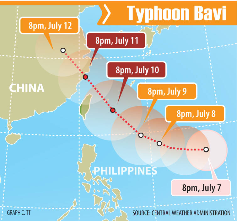
TAIPEI, Taiwan — Taiwan has entered a heightened state of preparedness after its Central Weather Administration (CWA) issued a land warning for Typhoon Bavi, cautioning that the storm is expected to bring its most significant impact from this evening through tomorrow as it continues to move toward the island.
The warning, released at 5:30 a.m., signals the increasing threat posed by the powerful tropical cyclone, which is forecast to unleash torrential rainfall, dangerous winds, and massive waves across several parts of Taiwan. Authorities have urged residents to closely monitor official weather updates and take necessary precautions as conditions are expected to deteriorate over the next 24 hours.
As of 8:00 a.m., the eye of Typhoon Bavi was located approximately 700 kilometers east of Oluanpi, Taiwan’s southernmost point, while moving northwest at a speed of 25 kilometers per hour. According to the CWA, the storm continues to pack maximum sustained winds of 162 kilometers per hour, with wind gusts reaching as high as 198 kilometers per hour. The typhoon also maintains a broad circulation, with a storm radius estimated at around 380 kilometers, making it capable of affecting a wide area even before its center approaches the island.
READ MORE ARTICLES:
- Super Typhoon Bavi, Papasok na sa PAR Bilang ‘Inday’
- Bagyong Domeng (Jangmi) Lalong Lumakas, Posibleng Maging Typhoon sa Sabado; Lalabas ng PAR sa Lunes
- Super Typhoon Sinlaku Hit the Mariana Islands, Unleashing Powerful Winds and Heavy Rains Across the Pacific Region
- Category 5 Super Typhoon Sinlaku Explosively Intensifies, Guam and Northern Marianas in Potential Direct Path
- Bagyong Basyang, Magdadala ng Matinding Ulan at Landslide sa Mindanao
Weather forecasters said rainfall will gradually intensify throughout the day, particularly in Taiwan’s mountainous regions. Northern, central, and southern mountain areas are expected to receive increasing precipitation beginning later today, with the most intense downpours anticipated from tonight until tomorrow.
Among the areas facing the highest risk are New Taipei City, Yilan County, Miaoli County, and Hsinchu County, where accumulated rainfall could exceed 350 millimeters within a 24-hour period. Such rainfall amounts significantly raise the risk of flash floods, overflowing rivers, landslides, and road collapses, particularly in mountainous and low-lying communities.
Central Taiwan’s mountain ranges and Hualien County on the eastern coast are likewise forecast to experience localized torrential rainfall, while mountainous sections of southern Taiwan could see prolonged periods of heavy rain capable of disrupting transportation and daily activities.
Despite showing signs of gradual weakening since last night, meteorologists emphasized that Typhoon Bavi should not be underestimated. Although its storm radius is expected to shrink slightly as it moves closer to Taiwan, the system remains powerful enough to generate hazardous weather conditions over large portions of the island. Forecasters stressed that weakening tropical cyclones can still produce life-threatening rainfall, damaging winds, and dangerous coastal conditions.
Marine hazards have already become evident along Taiwan’s eastern coastline. Over the past eight hours, wave heights of six meters or higher were recorded in Chenggong Township in Taitung County as well as on Orchid Island, highlighting the growing danger for coastal communities, fishermen, and maritime transportation. Authorities continue to advise the public to stay away from beaches, ports, and rocky shorelines due to the heightened risk of powerful waves and strong currents.
Wind conditions are also expected to worsen considerably as the typhoon draws nearer. Northern Taiwan could experience wind gusts ranging from 75 to 117 kilometers per hour beginning tonight and lasting until late tomorrow. Elsewhere across the island, gusts between 62 and 88 kilometers per hour are expected, increasing the possibility of fallen trees, damaged infrastructure, scattered power outages, and hazardous travel conditions.
Emergency response agencies have been placed on alert as local governments continue monitoring the storm’s development. Residents living in flood-prone, mountainous, and coastal areas are being encouraged to prepare emergency supplies, secure loose outdoor objects, and avoid unnecessary travel during the height of the storm.
With Typhoon Bavi expected to deliver its strongest effects within the next day, officials continue to remind the public that early preparation and strict adherence to weather advisories remain the best defense against the potentially dangerous impacts of one of the region’s most significant weather systems this season. / aptikons