Chinese authorities have activated a Level-IV emergency response across Hainan, Guangxi, and Guangdong as a tropical depression over the South China Sea is forecast to strengthen into a typhoon before making landfall. Officials have deployed emergency teams and intensified disaster preparedness efforts amid warnings of torrential rain, powerful winds, flash floods, and landslides that could affect millions of residents across southern China through the weekend.
NANNING, Guangxi, China — Chinese authorities have launched emergency flood and typhoon preparedness measures across several southern provinces as a developing tropical system over the South China Sea is expected to strengthen into a typhoon and bring days of dangerous weather, heavy rainfall, and potential flooding to millions of residents.
China’s State Flood Control and Drought Relief Headquarters on Thursday activated a Level-IV emergency response for flood control and typhoon prevention in Hainan Province, Guangxi Zhuang Autonomous Region, and Guangdong Province as meteorologists warned that the tropical depression could rapidly intensify before making landfall. The emergency activation reflects growing concerns over the storm’s potential to trigger widespread flooding, transportation disruptions, and other weather-related hazards across southern China.
READ MORE ARTICLES:
- Southern China, Typhoon Maysak Forces Evacuations Ahead Of Second Landfall
- THAILAND: 10 Monks Killed, Multiple Injured as 11-Year-Old Boy Drives Truck
- 21,000 Join Visayas Job Fairs for Skills and Careers
- Team Leyte Pilipinas Shines in Taiwan Cage Invitational
- Ex-Abuyog Vice Mayor, Son Slain; 3 Suspects Arrested
- Marilen Gonzales-Elizalde Explores Shanghai’s Timeless Beauty and Modern Luxury
The Ministry of Emergency Management announced that working groups have already been dispatched to frontline areas in Hainan Province to assist local governments and emergency agencies in coordinating preparedness efforts. These teams are tasked with supporting disaster prevention operations, monitoring weather developments, and ensuring that local authorities are prepared to respond quickly should conditions worsen.
According to weather forecasts, the tropical depression currently moving across the South China Sea is expected to strengthen into a typhoon on Thursday. Forecasters predict that the system will first strike the eastern coast of Hainan Island between Friday afternoon and Friday evening before continuing its northwestward movement. The storm is then expected to make a second landfall along the coastal region stretching from Guangxi in southern China to northern Vietnam sometime on Saturday afternoon or evening.
The projected path has raised concerns among emergency officials because the storm is expected to affect multiple densely populated regions within a relatively short period. Authorities are closely monitoring its development as weather models indicate that it could deliver significant rainfall across broad areas of southern China.
Meteorological agencies forecast that portions of Hainan, Guangdong, and Guangxi will experience prolonged periods of heavy rain beginning Friday and continuing through Sunday. Some locations may receive torrential downpours, while isolated areas could face extremely heavy rainfall capable of overwhelming drainage systems and triggering dangerous flooding.
Experts warn that saturated ground conditions combined with intense rainfall could increase the likelihood of flash floods, landslides, and river overflows, particularly in low-lying communities and mountainous regions. Residents living near rivers, coastal zones, and flood-prone areas have been urged to closely follow official advisories and prepare for possible emergency measures.
Local governments throughout the affected provinces have intensified disaster preparedness efforts ahead of the storm’s arrival. Emergency management agencies are reviewing evacuation plans, inspecting flood-control infrastructure, and ensuring that rescue personnel and equipment are ready for rapid deployment if necessary. Authorities are also coordinating with transportation, power, and communications sectors to minimize disruptions and maintain essential services during the severe weather event.
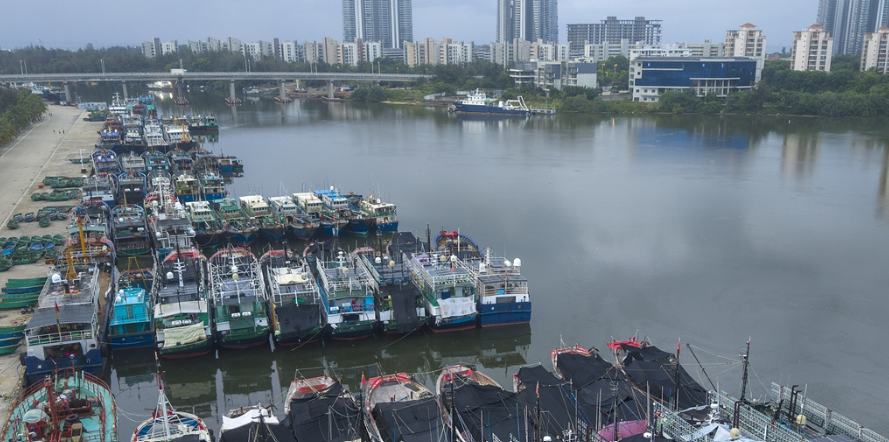
In Hainan Province, where the typhoon is expected to make its first landfall, officials have begun heightened monitoring of coastal communities vulnerable to strong winds and storm surges. Fishermen and maritime operators have been advised to return to port, while local authorities continue assessing risks to tourism facilities, transportation networks, and public infrastructure.
Meanwhile, Guangdong and Guangxi authorities are also preparing for the storm’s potential impact. Emergency officials are evaluating flood-prone locations, strengthening monitoring systems along rivers and reservoirs, and coordinating with local communities to ensure readiness should evacuations become necessary.
The activation of the Level-IV emergency response demonstrates the Chinese government’s commitment to taking precautionary measures before the storm’s arrival. Under China’s four-tier emergency management framework, Level I represents the highest level of response, while Level IV serves as an early-stage activation designed to mobilize resources and improve coordination among agencies before a situation escalates.
Weather experts emphasize that although the system has not yet reached typhoon strength, conditions remain highly dynamic, and forecasts could change as the storm develops over warm waters in the South China Sea. Such conditions often provide the energy needed for tropical systems to intensify rapidly, increasing the threat to coastal communities.
As southern China braces for the approaching weather system, authorities continue to urge residents to remain vigilant, monitor official forecasts, and take necessary precautions to protect lives and property. With heavy rainfall, powerful winds, and potential flooding expected across several provinces, emergency responders remain on high alert as the developing typhoon moves steadily toward land and threatens to become one of the most significant weather events affecting the region in recent weeks.
APTIKINS