North Korea’s underground nuclear tests may have triggered a long-term increase in earthquake activity around Mount Mantap, where the country conducted all six of its known nuclear tests, according to a new scientific study that identified 1,399 earthquakes in the area between 2008 and 2025.
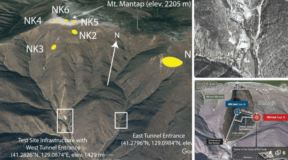
PYONGYANG, North Korea — A new scientific study suggests that underground nuclear testing by North Korea may have contributed to a long-term increase in earthquake activity around Mount Mantap, the mountainous area that hosted the country’s Punggye-ri nuclear test site.
Researchers analyzed seismic wave data recorded in the region from 2008 to 2025 and identified 1,399 earthquakes near Mount Mantap. The area is significant because North Korea conducted all six of its known underground nuclear tests there between 2006 and 2017, with the final and largest test carried out in September 2017.
ADSThe study, published in Science, was supported by the National Science Foundation of China and the National Research Foundation of Korea. Scientists said the pattern they observed was unusual because earthquakes associated with underground nuclear explosions have generally been expected to decrease relatively quickly after the initial disturbance.
Instead, seismic activity around Mount Mantap appeared to increase following the 2017 explosion, raising questions about how underground nuclear detonations can alter the Earth’s crust over a much longer period.
READ OTHER ARTICLES:
- North Korea nuclear tests may have triggered earthquakes near Mount Mantap
- DOJ Reaches Agreements With NYU, UPMC Over Transgender Care for Minors
- Catriona Gray Still Reigns as the Gold Standard of Beauty Queens
- Villagers Tie Jio Infocomm Technician to Cell Tower Over Network Woes
- At Least 26 Children Killed in DR Congo School Fire Stampede
- Kampo ni VP Sara Duterte, Handa sa Anumang Pagbabago sa Impeachment Trial
- vnadexpress.com Faces Scam Allegations Over Online Investment and Withdrawal Scheme
The earliest earthquake identified in the study occurred in 2013, following North Korea’s third nuclear test. Researchers said seismic activity remained relatively limited afterward, but a much clearer increase was observed after the country’s sixth nuclear test in 2017.
Kwang-Hee Kim, a professor in the Department of Geological Sciences at Pusan National University in South Korea and one of the study’s lead authors, described the seismic pattern as unexpectedly clear.
The researchers believe the 2017 explosion may have disturbed existing geological structures beneath Mount Mantap. Rather than the surrounding rock immediately returning to its previous condition, the explosion may have reactivated faults and fractures that had remained largely inactive.
One possible explanation involves the unusual shape and structure of Mount Mantap. According to the researchers, the mountain’s irregular topography and geological asymmetry may have contributed to the activation of at least two preexisting faults.
The nuclear explosion could have created additional fractures underground while reopening older cracks. Water entering those fractures could then increase pressure within the rock. As pressure changes, sections of the Earth’s crust can move along faults, potentially producing a sequence of earthquakes.
Scientists emphasized that the findings concern a possible relationship between nuclear testing and subsequent seismic activity, rather than evidence that every earthquake in the region was directly caused by the nuclear explosions.
The study’s observations are nevertheless notable because the area surrounding Mount Mantap had historically experienced very little seismic activity. Researchers examined historical records from China and Korea and found that the region had been unusually quiet before North Korea began its nuclear testing program.
The first five nuclear tests at the Punggye-ri site occurred between 2006 and 2016, while the sixth test, conducted on September 3, 2017, produced the strongest underground explosion associated with North Korea’s nuclear program.
That final test caused substantial geological disturbance around Mount Mantap. In the months that followed, scientists detected additional seismic events in the area, prompting renewed scientific interest in whether the mountain had been permanently altered by the explosion.
Sunyoung Park, an assistant professor in the Department of the Geophysical Sciences at the University of Chicago who was not involved in the research, said the broader significance of the findings could extend beyond North Korea.
Park noted that a disturbance that lasts only a short time can potentially produce consequences that remain detectable for years or even decades, illustrating how geological systems can retain the effects of major underground events.
The researchers’ findings also challenge the assumption that seismic disturbances associated with underground nuclear tests necessarily fade quickly. In previous cases, earthquake activity linked to nuclear explosions generally declined after the initial disturbance.
At Mount Mantap, however, the researchers observed a different pattern, with seismic activity continuing and appearing to increase over time.
ADSNorth Korea’s Punggye-ri site is located in the country’s northeastern region, near the border with China. The location was selected because of its mountainous terrain and underground geology, allowing nuclear tests to be conducted beneath the surface.
After the sixth nuclear test in 2017, North Korea announced that it would close the Punggye-ri facility. In May 2018, the country destroyed several underground tunnels and aboveground structures at the site in front of a group of invited international journalists.
The closure took place ahead of a planned summit between North Korean leader Kim Jong Un and then-U.S. President Donald Trump. At the time, the demolition was presented as a visible step toward shutting down the nuclear testing facility.
However, the scientific importance of Mount Mantap has continued long after the site’s reported closure. Seismic monitoring has allowed researchers to examine the geological consequences of the explosions and study how the Earth’s crust responded in the years that followed.
The new findings do not establish that North Korea’s nuclear tests are responsible for all of the earthquakes recorded around Mount Mantap. Instead, the researchers point to a strong temporal and spatial relationship between the nuclear explosions and the later increase in seismic activity.
The study provides another indication of the potentially lasting geological consequences of underground nuclear testing. While the explosions themselves occur within seconds, their effects on fractured rock, underground pressure, and existing faults can potentially continue for much longer.
For scientists monitoring the Korean Peninsula, Mount Mantap therefore remains an important natural laboratory for understanding how powerful human-made explosions interact with geological systems.
The findings also demonstrate why seismic monitoring remains important even after a nuclear test site has been closed. Earthquake patterns can provide information about changes beneath the surface that cannot be observed directly, particularly in locations where access for independent geological surveys is limited.
As researchers continue monitoring the region, additional seismic data could help determine whether earthquake activity around Mount Mantap eventually declines or continues at an elevated level.
The study ultimately highlights a broader geological lesson: although an underground explosion may be over within moments, the Earth’s crust can continue responding to the disturbance long afterward.
ADSMount Mantap: North Korea’s Nuclear Test Site and Its Lasting Impact
Mount Mantap, also known as Mantapsan, is a mountain located in North Korea. It is home to the Punggye-ri Nuclear Test Site, the country’s only known facility dedicated to conducting underground nuclear tests. Between 2006 and 2017, North Korea conducted six major nuclear tests beneath the mountain, choosing the site for several strategic reasons related to both safety and secrecy.
The selection of Mount Mantap was not arbitrary. Rising to 2,205 metres, the mountain consists largely of solid granite, a rock formation known for its exceptional hardness and durability. This thick and robust geological structure was considered suitable for containing the immense force of underground explosions. The dense granite bedrock could absorb significant explosive energy, helping to confine the detonations deep underground rather than allowing their destructive forces to spread outward. Equally important was the site’s potential to reduce the risk of radioactive leakage. The tests were conducted through horizontal tunnels excavated hundreds of metres beneath the surface, a design intended to contain radioactive gases and other hazardous materials underground. This containment strategy was intended to prevent radioactive substances from escaping into the atmosphere, reducing the likelihood of immediate detection and limiting potential cross-border environmental contamination.
Beyond its geological advantages, Mount Mantap offered another critical benefit: isolation. Located in a remote, mountainous region in North Korea’s northeast, the area is difficult to access and monitor from outside. Its rugged terrain and distance from major population centres made it easier for the country to conceal sensitive activities from foreign surveillance, allowing North Korea to conduct its nuclear programme with a greater degree of secrecy than would have been possible in a more accessible location.
The consequences of the nuclear tests have been profound and long-lasting. The final detonation, conducted on 3 September 2017, was believed to have involved a thermonuclear device and was the most powerful of North Korea’s six tests. The explosion caused significant damage to the mountain itself. The force of the blast is estimated to have reduced the peak’s height by as much as three metres, while large sections of the mountain’s interior collapsed. Scientists have used the term “Tired Mountain Syndrome” to describe the deterioration associated with repeated underground nuclear explosions, including extensive fracturing and weakening of the rock mass beneath the summit.
The effects extend beyond the mountain’s physical deformation. The repeated explosions altered the surrounding geological structure and were followed by seismic activity in the area. Researchers have recorded numerous small earthquakes near Mount Mantap, although the causes and relationship between individual seismic events and the nuclear tests vary and remain subjects of scientific study. These continuing geological effects demonstrate that underground nuclear explosions can have consequences that extend beyond the immediate blast site, leaving lasting changes to the mountain and its surrounding environment.
ADS- North Korea nuclear tests may have triggered earthquakes near Mount Mantap

- DOJ Reaches Agreements With NYU, UPMC Over Transgender Care for Minors
- Mark Zuckerberg Summoned as Facebook Faces Possible Suspension in Philippines
- August–September 2026 Nurses Licensure Exam Results Released; 28,652 Pass
- DepEd Benguet Bans Weekend School Activities for Rest
- Over 230,000 Fake Recruitment Posts Removed by Meta, TikTok Since 2022